Burning Decisions: Managing Forest Lands
Modeling tool reveals resource and ecosystem service trade-offs and synergies with climate and wildfire adaptation forestry

A study by Pacific Northwest National Laboratory and the U.S. Department of Agriculture-Forest Service’s Pacific Northwest Research Station provides insight into the resource and ecosystem service trade-offs and synergies among land management strategies to adapt forests to changing climatic and wildfire regimes. This information can assist land managers with the best approaches for protecting and benefiting forests, habitats, and ecosystems. Top-left untreated, top-right thinned, bottom-right burned, bottom-left after the burn in the Sinlahekin Wildlife refuge.
(Photos: John Marshall Photography)
Communities living in heavily wooded landscapes in the western United States are experiencing an increase in devastating forest fires that impact human lives, homes, habitats, and streamflow.
A warming climate, drought, fuels, and past management practices are the identified culprits.
Land managers have options for mitigating severe wildfires, such as thinning and controlled burning. But with approximately 500 million acres of public, private, state, and tribal forests supported by U.S. Forest Service (USFS) management, prioritizing which areas to focus these efforts with limited resources is difficult when trying to balance and prioritize the multiple needs of communities, tribes, land managers, and citizens.
Now, scientists from the Pacific Northwest National Laboratory (PNNL) and the U.S. Department of Agriculture-Forest Services’ Pacific Northwest Research Station have partnered to evaluate potential climate and wildfire adaptation scenarios and resulting benefits from restoration forestry. Benefits include increasing streamflow from winter snowpack and gaining revenue from using forest residues for bio-based products.
Their findings, published in an invited feature in Frontiers in Forests and Global Change, provide insight into the trade-offs and synergies among land management strategies. This information can assist land managers with finding the best approaches for protecting and benefiting forests, people, and ecosystems. The research was funded by the Department of Energy’s Bioenergy Technologies Office.
Decisions, decisions—creating a tool
For their study, the team created a decision support tool to evaluate synergies and trade-offs by land management scenarios when considering a variety of resources and ecosystem services. These types of tools ingest the results of sophisticated biophysical and statistical models that use a wide variety of data in a truly integrated modeling platform to allow visualization of tradeoffs and ranking of proposed scenarios with respect to desired outcomes.
“In our study, spatial decision support tools are important for determining where land management treatment options will have the greatest positive influence on the wildfire and climate vulnerability of forests, while considering biomass opportunities and their economic benefit, stream flows, carbon sequestration, and wildfire emissions,” said Mark Wigmosta, the PNNL chief scientist who participated in the study. “This information will help land managers design a path forward for directing their resources for the greatest payoffs.”
The tool is an application designed within the Ecosystem Decision Support System. The team used the USFS’s Forest Vegetation Simulator and PNNL’s Distributed Hydrology Soil Vegetation Model to implement four distinct treatment scenarios and assess the potential benefits derived from their application. The information was then fed into the decision support tool, which ranked the potential benefits from each scenario among each topic area at patch to watershed scales. That way, watersheds could be prioritized for treatment benefits, and patch areas could be identified as focal areas of important treatments across the team’s testbed area: the Wenatchee River Basin.
A wilderness testbed
The team’s testbed in north-central Washington State is a 3,450 square kilometer basin where more than 80 percent of the land is managed by the USFS, with the remainder in mixed ownership. The basin has cold, wet winters with an abundance of snow and hot, dry summers.
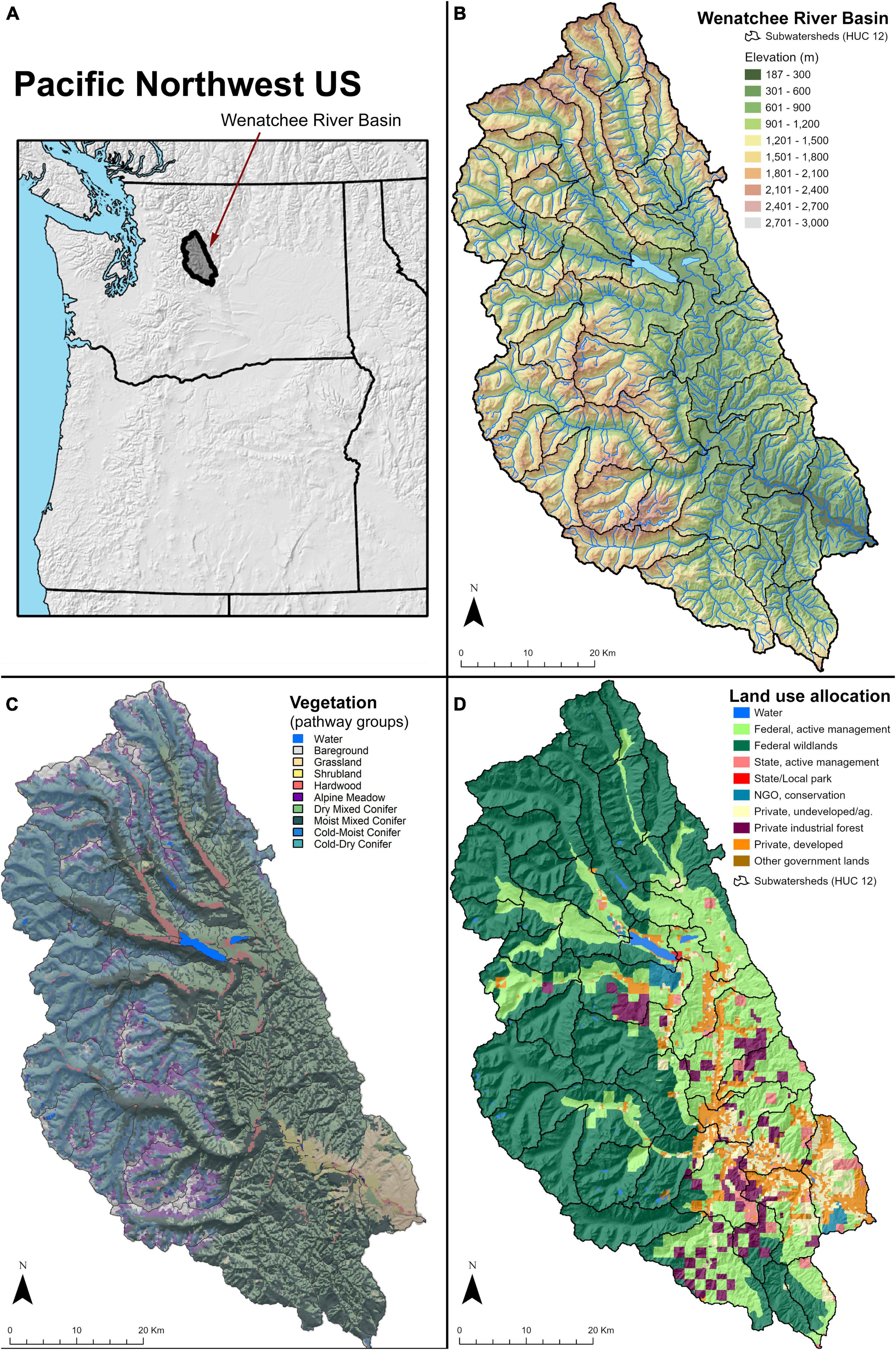
“The basin comprises a mixed landscape, with grass and shrub-steppe ecosystems in the lowest elevations, dry pine and mixed-conifer forests in the middle elevation, and sub-alpine cold forests, meadows, and heathlands at the highest elevations,” said Paul Hessburg, the U.S. Department of Agriculture-Forest Services’ Pacific Northwest Research Station chief scientist for the study. “Thus, the mix of landscapes and forest types requires a broad range of land management activities, options, and tools.”
Scenarios to make an impact
The team selected four key topic areas for forests and their associated social and ecological systems:
- Streamflow, where forest restoration activities could increase streamflow and flow duration from the melting snowpack. Water availability in the Western United States largely depends on mountain snowpack, which is important for salmon recovery, water temperature, and viability of regional fish. It provides water to reservoirs that can be of considerable value for agriculture and electricity generation. High priority was given to locations where forest adaptation treatments had the potential to improve forest resilience and provide for increasing snowpack by reducing losses and increasing peak snow water content—all which could lead to increased annual and late-season flows.
- Wildfire hazard reduction, where restoration activities could reduce the occurrence of severe wildfire and prolonged smoke emissions. The team also modeled carbon retained in live forests and fine particulate emissions reductions that could positively influence human health.
- Biomass production, where restoration could yield merchantable timber and non-merchantable residues, such as wood chips, that can be collected and processed for bioenergy.
- Economic feasibility, where restoration could produce enough revenue through biomass extraction to offset some or all operational costs.
The team then designed four restoration scenarios and compared them to a “No Treatment” or business as usual (BAU) scenario to determine the relative impacts on the four topic areas:
- Prescribed fire only, or BurnOnly, is where the team simulated prescribed burning during moderate fire weather conditions, yielding low- to moderate-severity fire. Burning was applied to all forested patches on the landscape, including wilderness.
- Mechanical fuel reduction and biomass production, or MaxBiomass, is a scenario which maximized the amount of biomass removed in small- to medium-sized trees in a typical fuel reduction thinning treatment. This scenario was restricted to actively managed public and private lands and was not applied to wilderness and roadless areas.
- Gap-based thinning designed to optimize streamflow, or IdealWater, is a scenario that addresses forest gaps of optimal sizes which can enhance peak snow accumulation and duration. This scenario was designed to optimize late-season streamflow and snow water content. Thinning maximized snow accumulation by minimizing the amount of snowfall captured by the tree canopies while maintaining adequate shading for the snowpack. This scenario was applied to all forested land using thinning and fire treatments, as appropriate to the land allocations.
- Principle-based scenario, or RA1, is a five- to 10-year land management scenario created by combining other approaches, such as burning and thinning, in various aspects of the landscape to restore pattern and complexity of landscapes in a manner that would bring greater wildfire and climate resilience to landscapes and begin to mimic a more naturally resilient state.
The results roll in
“What we found is that the principle-based restoration scenario—RA1—maintained the strongest synergies across all potential topics, demonstrating this scenario is a viable landscape restoration strategy for achieving multiple land management objectives,” said Hessburg.
When compared to the BAU scenario, the patches where the principle-based restoration scenario was implemented showed large reductions in wildfire hazards—ranging from 25 to 93 percent. It also reduced smoke production from future wildfires by up to 33 percent, increased maximum snow water by 10 percent, and annual streamflow by as much as seven percent.
Other findings included:
- Canopy cover was reduced across all scenarios, but the IdealWater scenario produced the greatest canopy reduction. In fact, this scenario produced the highest scores throughout the landscape, but it represented the least realistic treatment scenario when considering other ecosystem services. “This scenario did a great job of preserving the snowpack, but the economics for producing gaps in the entire forest—both managed and wild—is challenging,” said Wigmosta. “It meets a main objective of increasing snowpack and water storage, but the gaps, especially at the upper elevation, require too much labor.”
- The team found that the BurnOnly scenario provided no direct economic or biomass outputs, and that a strong positive correlation existed among the hydrology and wildfire topic areas for all scenarios except BurnOnly.
- The MaxBiomass scenario, which considered collection and hauling costs as well as distance to roads, produced high scores for actively managed forests. However, that scenario was limited in the overall benefit to streamflow and wildfire hazards due to the large extent of wildlands.
“What we found is that the principle-based restoration scenario—RA1—maintained the strongest synergies across all potential topics, demonstrating this scenario is a viable landscape restoration strategy for achieving multiple land management objectives.” - Paul Hessburg
Full study results are available in the article.
What’s next?
The team is working with the Washington State Department of Natural Resources to create a management-grade tool for use in project planning in the Nason Creek Watershed. They are also running simulations over a 100-year period while implementing future climate and weather scenarios. These simulations will allow ongoing wildfires to remain unsuppressed under the worst fire weather conditions to determine the level of pattern treatments that may be required to tip landscapes in the direction of more benign fire behavior.
“After a fire, regrowth and other factors continually alter the landscape, while economic and logistical factors make it necessary to prioritize and stagger planned treatments within these evolving conditions,” said Wigmosta. “We will be working to evaluate incremental treatments and response to dynamic vegetation conditions over the 21st century.”
Published: June 14, 2022