
High Performance Geophysical Imaging
Subsurface electrical geophysical properties are sensitive to the parameters that govern flow and transport in the vadose including grain size distribution, packing, and saturation. The same electrical properties are also sensitive to geochemical parameters altered by amendment delivery and subsequent remedial processes such as pore space geochemistry, mineralogy, and pore-grain interfacial electrochemistry. Therefore, changes in electrical properties estimated via 3D geophysical monitoring techniques are proxies for corresponding changes in relevant remedial properties (e.g. changes in pore geochemistry, pore-grain interface alterations, changes in saturation etc). Pre-injection images of electrical properties provide information and reduce uncertainty concerning the distribution of parameters that govern flow and transport. Time-lapse images of changes in electrical properties can be used to monitor amendment transport and delivery in 3D, and to monitor post-delivery remedial processes using changes in electrical properties as proxies for changes in geochemical properties. Furthermore, 3D electrical geophysical monitoring infrastructure can be installed relatively inexpensively, and often operated autonomously at little cost.
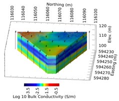
Figure 1. 3D direct-current electrical resistivity structure of the Hanford 300 Area IFRC well field.
Two primary challenges inhibit the utility of electrical geophysical imaging for monitoring amendment delivery and post delivery remedial performance. First, the physical relationships between electrical properties and hydrogeological/geochemical/interfacial are highly complex, site specific, non-unique, and therefore difficult to quantify with certainty. Second, the computational demands of time-lapse geophysical imaging are often prohibitive, particularly in 3D. Methods for addressing the computational demands of 3D monitoring are reviewed in this document, particularly concerning complex resistivity (CR) method which high applicable to in situ monitoring.
CR imaging is a particularly useful method for monitoring vadose zone amendment delivery and remedial performance because CR is sensitive to (among others) changes in saturation, pore fluid geochemistry, and pore-grain boundary characteristics. However, optimal 3D CR monitoring is not feasible on current desktop computers, and generally requires execution on high performance parallel computing systems. Current multi-channel CR data collection systems can acquire immense amounts of data in short periods of time. If they can be processed efficiently, these data sets can provide high resolution 3D estimates of electrical properties (or changes therein) in space and time. However, current commercial CR processing codes are designed for 2D or small scale 3D characterization efforts, and are inadequate for handling time-lapse 3D data sets, limiting the potential of CR imaging. This limitation is addressed by developing parallel geophysical modeling and inversion codes capable of executing on parallel computing systems to efficiently address the computational requirements of 3D time-lapse CR imaging.
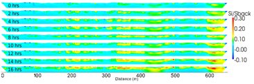
Figure 2. Time-lapse direct-current resistivity adjacent to the Columbia River near the Hanford 300 Area. Changes in resistivity are caused by influx of river water due to rising river stage. Areas of greatest exchange mark areas of active hyporheic exchange.
Through funding from the Department of Energy Office of Environmental Management (EM), a parallel geophysical modeling and inversion code developed partly under funding from the Department of Energy Office of Science (SC) is being modified for 3D time-lapse CR imaging. This code was developed at the Idaho National Laboratory and was originally designed for direct-current resistivity and time-domain induced polarization imaging, which is generally speaking a subset of CR imaging. It has been extensively tested and employed for 3D electrical resistivity characterization of the Hanford 300 Area under EM funding for the 300 Area Integrated Field Research Challenge (figure 1). Under SC funding, the code is being used to monitor hyporheic exchange along a 700 m stretch of the Columbia River adjacent to the 300 Area in an effort to better understand hydrodynamic forces driving uranium transport in the area (figure 2). Under ESTCP funding, the resistivity imaging code is being used to monitor amendment delivery and performance during a TCE bioremediation application at a superfund site in Brandywine MD (figure 3). In this case, continuous 3D automated resistivity monitoring has been successfully demonstrated over two (and counting) years, and has provided 3D time-lapse images of evolving amendment distribution, and the subsequent sequence of bio-remedial processes. Understanding of the 3D geochemical evolution revealed through the time-lapse resistivity monitoring has been validated by point sampling in access wells.
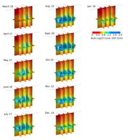
Figure 3. 3D time-lapse direct current resistivity images showing the evolving distribution of a lactate-based bio-amendment. Inverse images are produced daily.
Direct current resistivity is a small subset of the complex resistivity method, whereby the capability of soils to store and transfer charge is measured at different frequencies. Because the mechanisms governing frequency dependent charge storage and transfer are directly related properties governing or affected by amendment transport and remedial performance, CR imaging has the potential to provide much more information concerning 3D amendment distribution and subsequent geochemical alterations than direct-current resistivity imaging alone. However, CR monitoring has been underutilized in practice due primarily to the computational demands of inverting CR data. These demands are being addressed under EM funding by modifying the parallel resistivity and IP imaging code developed under SC and ESTCP funding to provide efficient multi-frequency CR imaging capabilities. This effort is coordinated with EM funded research by Lawrence Berkeley National Laboratory to understand how foam delivery influences CR. This will ultimately provide the capability to monitor CR with high spatiotemporal resolution, and to understand how 3D changes in CR are diagnostic of 3D foam amendment delivery and remedial performance.